Best Hikes in the South Island of New Zealand - Top Trails, Difficulty Levels, and Practical Tips
- Radina Loveday
- new zealand
Subscribe for the latest blog posts!
You’ll find trails that match whatever pace you want- jaw-dropping day walks, multi-day classics, family-friendly paths, and wild backcountry routes that feel miles from anyone else.
If you want a quick list of the must-do hikes, expect to discover Milford and Routeburn, plus coastal and alpine options that suit any skill level.
This guide breaks trails down by type and region, with practical notes on seasons, safety, logistics, and where to stay so you can plan a trip that fits your time and fitness.
Scroll on to match the right hike to your goals and start mapping out an unforgettable South Island adventure.
Top Iconic Hikes in the South Island
Each route offers distinct alpine scenery, reliable hut systems, and multiday logistics: plan transport, hut bookings, and weather windows carefully.
You will encounter steep climbs, river crossings on some tracks, and variable mountain weather even in summer.
Routeburn Track
The Routeburn Track runs roughly 32 km between Glenorchy/Mount Aspiring and The Divide near Milford Road.
You will climb through beech forest to alpine tussock, reaching panoramic viewpoints such as Key Summit and the Harris Saddle. Expect 2–4 days depending on pace; huts and campsites are managed by the DOC and require advance booking in high season.

Carry layered clothing, a waterproof shell, and at least one warm midlayer; temperatures can change quickly above the bushline. Water is generally available, but treat or filter it where required. Trail surfaces vary from packed track to steeper, rooty sections and metal ladders at steeper drops.
Milford Track
The Milford Track is a classic 53.5 km route through Fiordland National Park, usually completed in 4 days. You will start at Glade Wharf and finish at Sandfly Point, passing waterfalls, rainforest, and the iconic Sutherland Falls. The Department of Conservation operates huts and a staged itinerary; hut reservations and boat transport are essential in summer.

Be prepared for heavy rainfall and river crossings; pack waterproofs and good gaiters.
The track is linear, so coordinate transport back to Te Anau or Milford Sound. Guided options run regularly and include transfers if you prefer an organized experience.
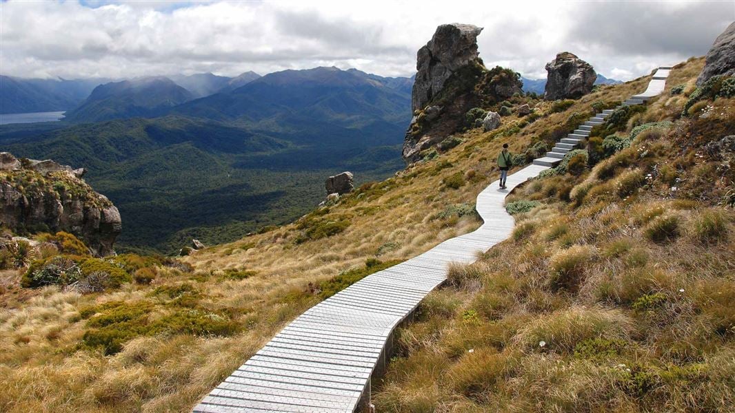
Kepler Track
The Kepler Track forms a 60 km loop that starts and finishes at the Rainbow Reach/Control Gates near Te Anau. You will ascend to alpine ridgelines with sweeping views of Lake Te Anau and the surrounding mountains before descending through beech forest. Typical itineraries run 3–4 days; huts and campsites are spaced to match reasonable daily stages.

The track has sustained climbs and exposed ridge sections where the wind can be strong. Bring a map, headlamp, and stove (if staying in huts that allow cooking), and check DOC hut availability. The loop format simplifies logistics because you begin and end at a single access point.
Spectacular Day Hikes
These walks deliver high-value views in a single day: steep, well-graded ascents to panoramic ridgelines, a classic alpine valley with easy terrain, and a short, glacier-front trail with minimal technical demands. Expect clear markers, seasonal crowds, and gear for sun, wind, and sudden weather shifts.
Roy’s Peak Track
Roy’s Peak rises above Lake Wanaka and rewards you with a long, steady ridge climb and expansive lake-and-mountain panoramas. The track gains about 1,200 m over roughly 8–10 km one-way; plan 5-7 hours return depending on fitness and photo stops. Start early to avoid the busiest periods and harsh late-afternoon winds.

Trail surfaces are a mix of well-graded gravel and exposed tussock slopes. Wear sturdy shoes and bring sun protection-the exposure is constant. If you have limited time, shorten the outing by turning back from the ridge at a viewpoint; the views remain impressive.
Ben Lomond Track
Ben Lomond offers a true alpine summit experience above Queenstown with varied terrain from forest to scree. The full return is about 11–14 km with ~1,200–1,400 m ascent; expect 6–8 hours for the summit trip. The final section is steeper and exposed; use trekking poles if you prefer extra stability. You can combine the hike with the Skyline Gondola to cut 800–900 m of ascent and save time.

The full walk from the Queenstown Gardens or nearby trailheads gives a better sense of the route and conditions. Carry layers for wind and sudden temperature drops near the top.
Hooker Valley Track
Hooker Valley Track runs from White Horse Hill to the moraine and lake at Mount Cook National Park.
This easy, well-formed trail is about 10 km return with minimal elevation change and typically takes 3–4 hours at a relaxed pace. The path crosses three swing bridges and finishes at the glacier-fed Hooker Lake with close views of icebergs.

The track suits most fitness levels and is often clear of technical hazards, but the weather at altitude can change rapidly. Bring a waterproof layer and a warm hat, even on fine days. Photography opportunities and wildlife (alpine daisies, tussock, birds) make this an accessible day outing with big visual payoff. Check if it is open or still close at the time you are reading this.
Adventure Multi-Day Treks
These routes deliver remote coastal scenery, wild native forest, and high-country valleys. Expect hut systems, backcountry navigation, and variable weather - book huts or campsites in advance and pack for rain and wind.
Rakiura Track
The Rakiura Track circles the southern coast of Stewart Island over 32 km, usually done in 3–4 days. You cross coastal dunes, dense rimu and rata forest, and coastal lookout points that often host kiwi at night.
Huts and campsites are run by the Department of Conservation (DOC); you must book in summer. Trails are well-formed but include muddy sections and boardwalks, so waterproof boots and gaiters help. You will ferry to Oban from Bluff to start; factor ferry schedules into your plan. Wildlife viewing is a major highlight.

Stewart Island has high kiwi density and abundant birdlife like kaka and tui. Bring a headlamp for evening kiwi searches and keep noise low near hut areas.
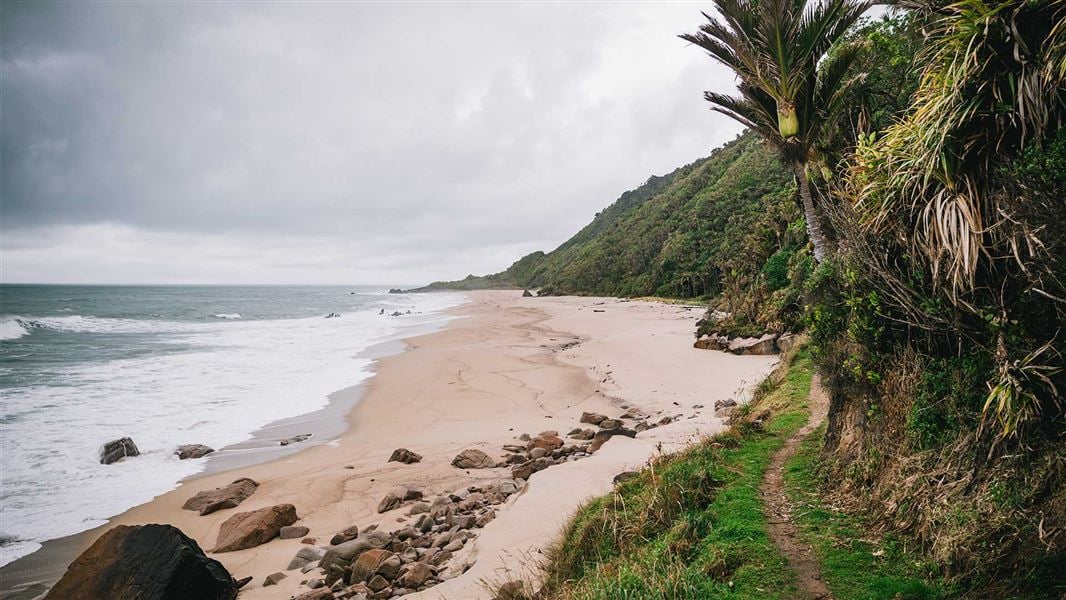
Heaphy Track
The Heaphy Track spans 78 km between Golden Bay and Karamea, typically 4–6 days depending on your pace.
You traverse contrasting terrain: golden beaches, limestone bluffs, nikau palm forest, and alpine bluffs in its upper reaches. DOC huts sit about a day apart; booking is essential in peak season.
Track surfaces vary from compacted gravel to soft, wet boardwalks. Tides matter at beach sections—check local advice before planning a low-tide crossing. The weather can switch rapidly, especially on exposed coastal and alpine sections.
Pack layered clothing, waterproofs, and navigation tools. You’ll find clear signage, but river crossings after heavy rain can become hazardous; follow DOC warnings.
Greenstone and Caples Tracks
The Greenstone and Caples Tracks form a linked circuit in the Fiordland/Mount Aspiring area, covering roughly 30–60 km depending on route choices and side trips. You move through beech forest, braided river valleys, and alpine basins with expansive mountain views.
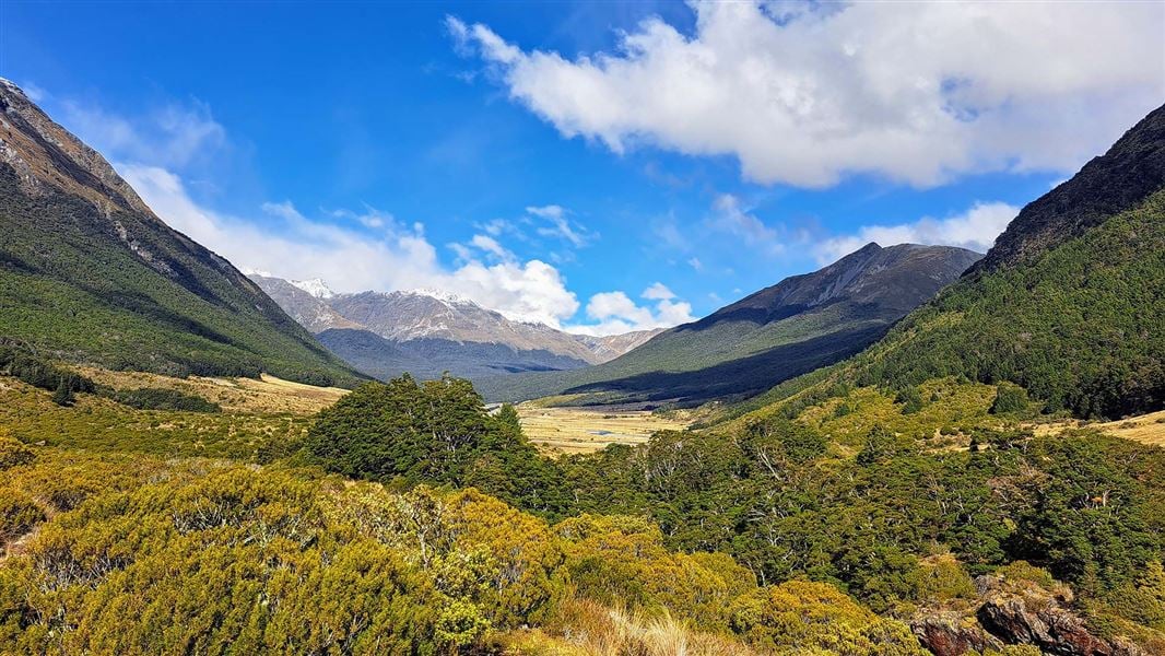
Huts are spaced for 1–2 day stages; bookings are required for busy months. Trails include river flats, muddy sections, and steep sidles. Sturdy boots and trekking poles improve comfort. You can connect to the Routeburn or extend into the Kepler if you want a longer trip. Water crossings and river levels can change quickly after rain.
Carry a detailed map, a personal locator beacon if you’ll be solo or beyond cell range, and treat drinking water from streams.
Family-Friendly Hiking Trails
These walks offer short, well-formed tracks with reliable facilities, scenic highlights, and minimal elevation gain. Expect easy navigation, boardwalks or gravel paths, and viewpoints suited to all ages.
Lake Matheson Walk
Lake Matheson lies near Fox Glacier and gives you one of the South Island’s most famous mirror-reflection views of Aoraki / Mount Cook and Mount Tasman. The loop is about 2.6 km and takes roughly 1 hour at a relaxed pace. The track is mostly boardwalk and compacted gravel, making it suitable for strollers and children who can walk short distances.
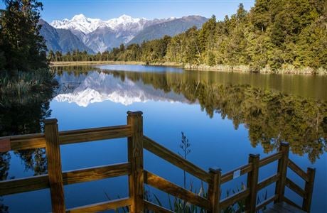
Facilities include a signed car park and toilets near the start. Wear layered clothing because the weather can change quickly, and keep to the marked track to protect fragile vegetation around the lake.
Blue Pools Track
The Blue Pools Track sits in the Haast Pass area and gives you a short, flat walk to clear, glacier-fed pools in the Makarora River. The return trip is about 1.4 km and takes 20–30 minutes, with native beech forest and a swing bridge that kids often enjoy crossing.
The track surface is mostly gravel and boardwalk, so it’s easy underfoot but can be muddy after rain; bring waterpro of footwear. There’s a small car park and picnic area at the trailhead, but no staffed facilities, so pack water and snacks. Keep children within sight on the bridge and river edges; the pools are deep and deceptively cold.
Secluded and Off-the-Beaten-Path Walks
Expect multi-day routes through remote alpine basins, beech forest, and coastal ridge country.
Both tracks require good planning, solid boots, and an acceptance of limited facilities and changing weather.
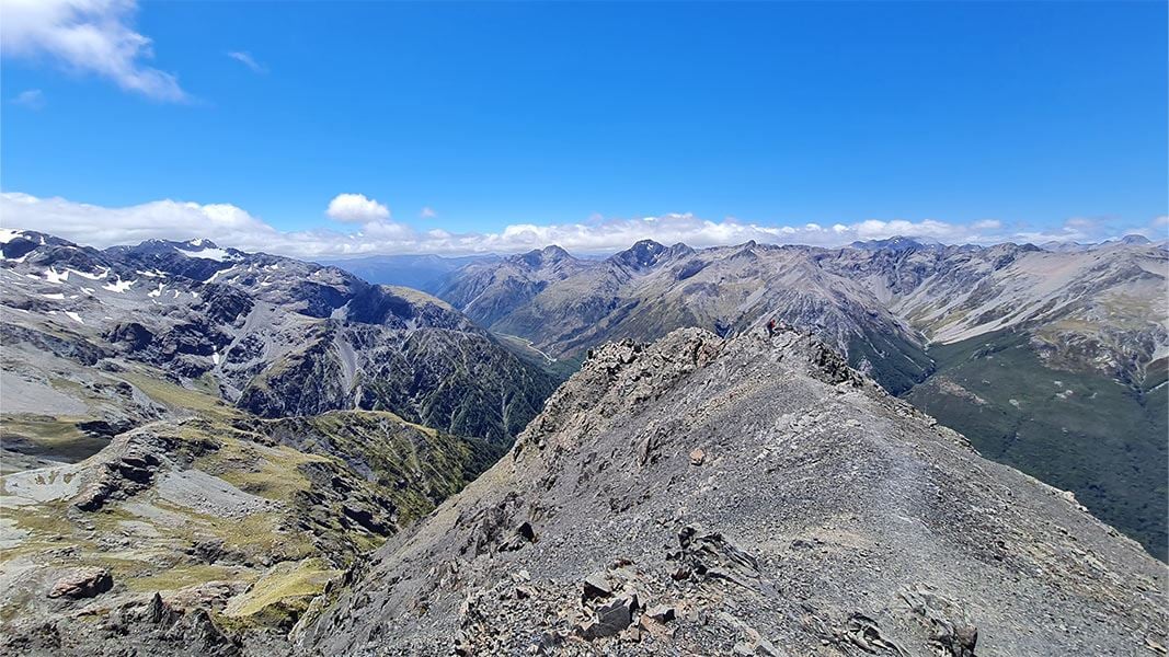
Gillespie Pass Circuit
Gillespie Pass Circuit sits above Lake Tekapo and winds through high alpine passes, tussocklands, and glacial-formed valleys. You start from the Caroline Creek or Two Thumb Range end, depending on access; expect steep ascents, loose scree, and sustained exposure on the pass itself.

Navigation can be demanding in cloud or snow, so carry a map, compass, and headtorch and know how to use them. Huts are backcountry-style and usually require booking with the DOC system; pack a stove and warm sleeping layers. You’ll cross river braids in summer, check river conditions, and time crossings in low flow.
Wildlife and clear night skies reward effort: you can see kea, alpine tussock habitat, and outstanding mountain views with far fewer people than on Great Walks.
Hump Ridge Track
Hump Ridge Track skirts coastal cliff tops and forest near southern Southland, offering a four-day loop with dramatic headlands and secluded beaches. The track moves between lowland rainforest, river terraces, and coastal ridges, so expect muddy sections and boardwalks in wet weather; strong footwear and gaiters help. Huts are rustic but well-maintained; you’ll need to pre-book and carry a sleeping bag liner and cooking gear.
Sections of the trail involve steep climbs to viewpoints and narrow ridge walking where wind can be strong, so check tides and weather forecasts before you go. You’ll pass viewpoints over Foveaux Strait and remote farming country, with very limited cell reception - plan supplies and transport logistics in advance.
Coastal Walking Experiences
Expect sheltered bays, golden sand, and easy-to-moderate trails with frequent water taxi or boat access. Both routes reward you with native bush, clear tidal waters, and chances to see seals, dolphins, and native birdlife.
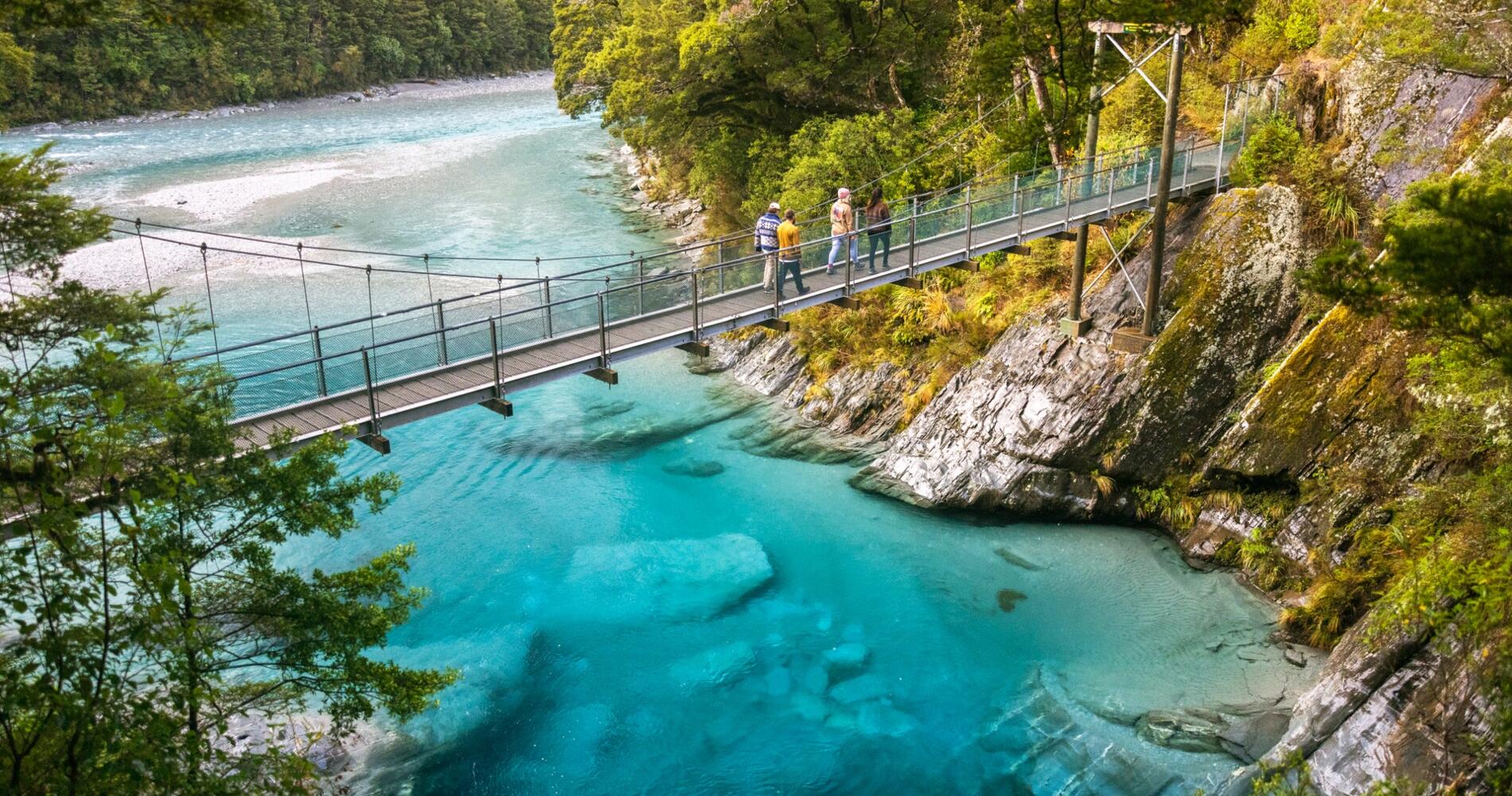
Abel Tasman Coast Track
The Abel Tasman Coast Track runs along the northern tip of the South Island and is best known for its beaches and frequent water-taxi pickups. You can walk day sections from Marahau or Totaranui, or through-hike 60 km over 3–5 days, staying in DOC huts or beachfront lodges.
Tide planning matters: several river crossings depend on tides and weather, so check the daily tide charts and book water taxis in advance during peak season.

The trail surface is mostly compact dirt and boardwalk with short, steeper sections; sandals or lightweight hiking shoes work for beach approaches, but sturdy footwear helps on uneven tracks. Expect clear swim spots, kayak rental options from main villages, and organized transfers that let you mix walking and boating.
Queen Charlotte Track
The Queen Charlotte Track sits in the Marlborough Sounds and offers 70 km of ridge and coastal walking with frequent elevation changes and panoramic harbour views. Most walkers take 3–5 days; you can combine single-day sections with water taxis between Anakiwa, Ship Cove, and Torea Bay to tailor distance and difficulty.
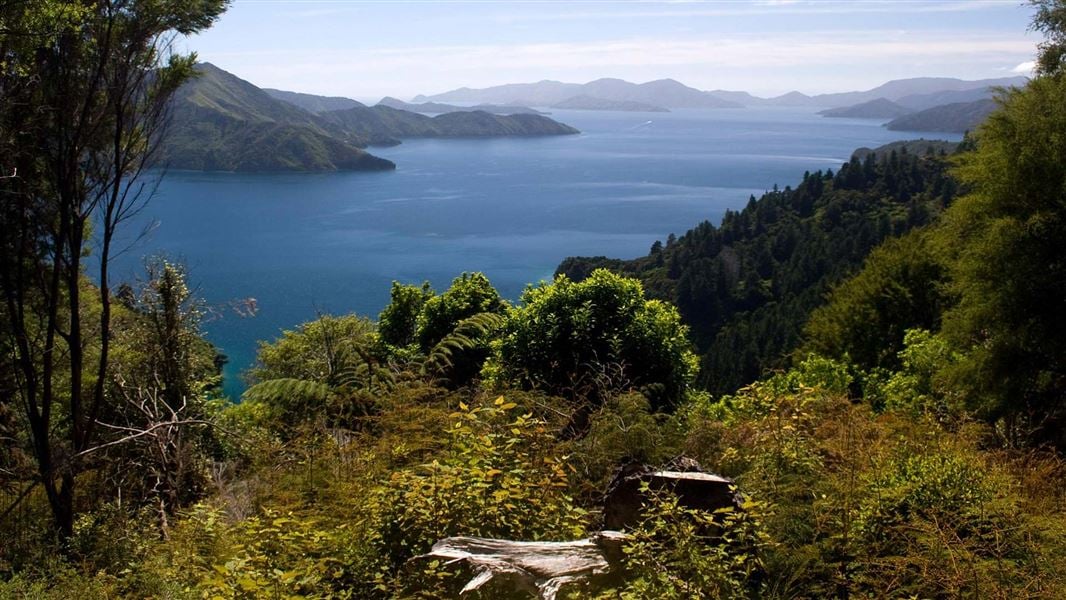
The trail alternates steep climbs and sheltered coves, so prepare for rocky ridge paths and rooted forest sections. Accommodation ranges from campsites and Department of Conservation huts to private lodges and cottages - book early for summer. Bring insect repellent for bushy stretches and plan logistics around water-taxi timetables if you need one-way transport or luggage transfer.
Alpine and Mountain Hiking Routes
Expect steep climbs, exposed ridgelines, and alpine weather that can change within an hour. You will need good fitness, sturdy boots, windproof layers, and navigation skills for these routes.
Mueller Hut Route
The Mueller Hut Route starts from the White Horse Hill campsite near Mount Cook Village and climbs through scree and alpine tussock to a stone hut sitting above the Hooker Valley glacier. The track gains about 700–900 m depending on the exact start and takes 3–4 hours one-way for fit walkers; allow extra time for snow or slow footing.
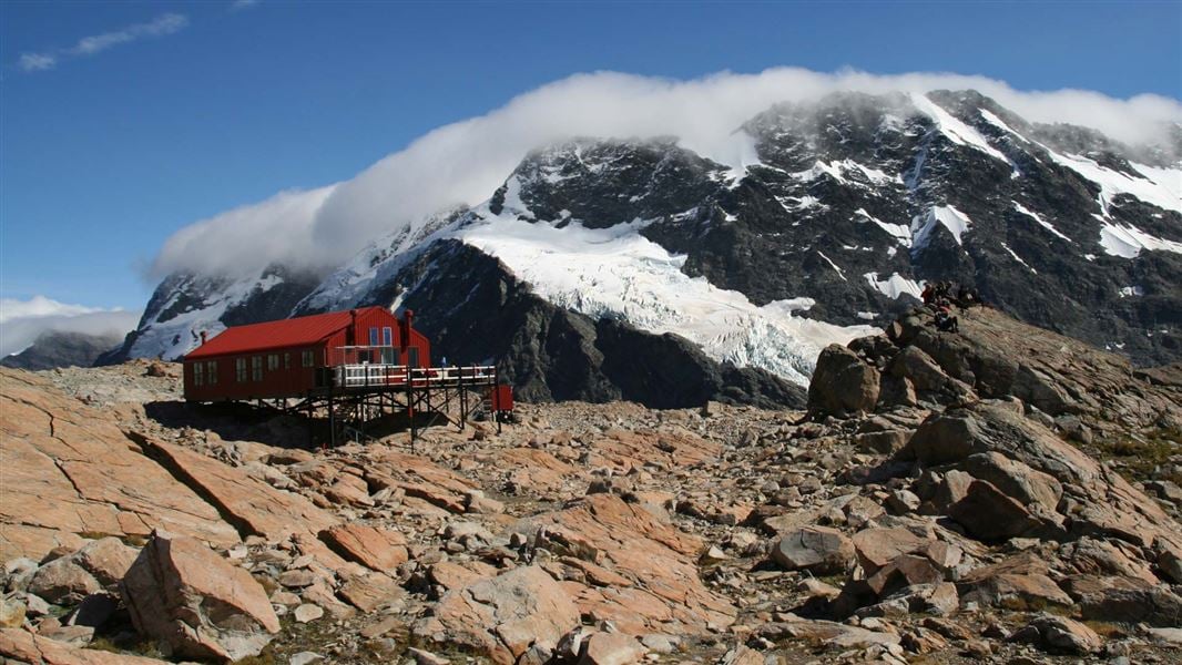
You’ll pass moraine viewpoints and narrow, sometimes exposed ridge sections where a steady head for heights helps. In summer, the path is clear but can be icy early or late season; carry crampons and an ice axe if snow remains.
Mueller Hut provides panoramic views of Aoraki/Mount Cook and the Hooker Glacier. Book hut bunks through DOC or plan a well-equipped camp if you stay outside the hut.
Avalanche Peak Track
Avalanche Peak climbs from Arthur's Pass village up a steep, marked route to a sharp summit ridge at about 1,833 m.
The return loop via Goat Creek or the Otira Valley is less common; most people do the out-and-back, which typically takes 4–6 hours depending on conditions and fitness. The trail is rocky with loose scree and exposed sections that require careful footing and surety on steep slopes. Winter and shoulder seasons frequently have snow and ice - carry crampons and an ice axe, and check avalanche forecasts before you go.
From the summit, you get direct alpine views across the Southern Alps and down into the Otira Gorge. Start early to avoid rockfall, strong winds, and limited visibility that develop later in the day.
Hiking Safety and Preparation
Plan your route and check the weather before you go. South Island conditions change quickly, especially in alpine and coastal areas, so update your plan the morning of your hike.
Carry a map, compass, and a charged GPS or phone with offline maps. Do not rely solely on your phone’s signal; cell coverage is patchy in many tracts of the island. Pack layers for cold, wind, and rain; expect sun and strong UV even when cool.
Bring at least extra insulating and waterproof layers, a hat, and gloves for alpine climbs. Bring enough food and water for longer than the planned duration. Water sources can be plentiful, but treat or filter where unsure; carry spare snacks with high calories and electrolytes.
Use suitable footwear and test new boots before multi-day trips. For rough or alpine terrain, gaiters, trekking poles, and crampons or an ice axe may be required, depending on season and route.
Tell someone your plan and expected return time. For multi-day or remote hikes, register with local DOC huts or huts’ booking systems where applicable and consider a personal locator beacon (PLB) or satellite messenger.
Learn basic navigation, first aid, and how to read mountain weather forecasts. If unfamiliar with avalanche, river-crossing, or glacier hazards, hire a guide or join a guided trip.
Quick checklist (bring these every time):
Map + compass, GPS/phone with offline maps
Weather-appropriate layers, rain shell
Food, water
First-aid kit, headlamp, spare batteries
Emergency beacon or satellite communicator
Best Seasons and Weather Considerations
Spring (September-November) brings rapid snowmelt at higher elevations and strong wildflower displays in valleys. You’ll find fewer crowds on popular tracks, but expect muddy trails and variable conditions that may require gaiters.
Summer (December-February) offers the warmest, most stable weather and long daylight hours. Alpine routes and multi-day treks are accessible, but popular huts and campsites fill quickly, and afternoon thunderstorms can develop.
Autumn (March-May) gives crisp air and vivid foliage in some regions, with generally stable weather and cooler nights. You’ll encounter fewer people on the tracks, and still many open routes before winter closures start.
Winter (June-August) means snow, ice, and route closures in alpine areas; many huts remain closed or have limited access. If you plan winter hiking or mountaineering, carry crampons, an ice axe, and avalanche safety gear, and only go if you have experience or a qualified guide.
Key practical tips:
Check the NZ Transport Agency and Department of Conservation (DOC) alerts for track closures and hut availability.
Pack layered clothing, a waterproof shell, and sun protection regardless of the season.
Monitor weather forecasts closely; rapid southerly changeups are common across the island.
Conservation and Responsible Hiking
You play a direct role in protecting the South Island’s wild places.
Follow New Zealand’s Leave No Trace principles: plan ahead, stick to tracks, dispose of waste properly, and minimise campfire impact. Respect wildlife and cultural sites. Keep distance from birds and seals, avoid disturbing nesting areas, and follow signage at iwi (Māori) sites and wahi tapu (sacred places).
Pack out what you pack in. Use resealable bags for food and rubbish, and carry a small trowel to bury human waste where required - 1-2 cm deep is often insufficient; check local DOC or park guidance for proper procedures.
Choose low‑impact camping and sanitation. Use designated campsites or huts, treat water before drinking, and use biodegradable soap sparingly at least 100 metres from waterways. Support conservation with permits, hut fees, and donations. These funds maintain tracks, toilets, predator control, and native species recovery programs that keep trails open and healthy.
Simple habits make a big difference:
Keep dogs and pets off conservation land unless allowed.
Avoid feeding wildlife.
Report hazards or illegal activity to DOC or local rangers.
Your thoughtful choices help preserve the scenery and biodiversity that make South Island hikes exceptional.
South Island Logistics and Accommodation
Plan travel between regions by bus, rental car, or scheduled shuttle services. Distances look short on a map but often take longer due to winding roads and mountain passes. Book transport early in peak season (Dec–Feb) to lock in times that match trailheads and hut check-in windows. Choose accommodation that matches your hiking style. For multi-day Great Walks, you’ll use DOC huts or commercial lodges; book those months ahead.
In towns, you’ll find hostels, motels, and boutique hotels. Compare location, parking, and gear storage. Carry a small kit of essentials when moving between towns: wet-weather layers, spare socks, a dry bag for documents, and charged power banks.
Check opening hours for visitor centres and local transport desks. Services can be limited in smaller towns and off-season.
Use this quick checklist when planning:
Booking: Reserve huts, campsites, and ferries early in summer.
Transport: Match shuttle times to trailheads; allow buffer time for delays.
Gear storage: Confirm if your accommodation will hold a large pack.
Weather: Expect rapid changes; plan flexible arrival/departure days.
If you drive, factor in fuel stops - some rural stretches have long gaps between stations.
When you rely on public transport, keep printed or offline copies of schedules and confirmations in case mobile coverage is patchy.